
Backpacking Onion Valley to Kearsarge and Matlock Lakes over Kearsarge Pass is about 13.5 miles. This trail gains roughly 3,727 ft of elevation and is rated as a hard trail with lots of foot traffic. This is an out and back trail that follows up Kearsarge Pass.
Permits
Permits are required for all overnight trips in Eastern Sierra’s and can be reserved via recreation.gov
60% of permits are released on a first come first served basis 6 months ahead of your start date (so for June 4th, you would book January 4th), and the other 40% are released 2 weeks prior at 7am.
Check for your desired backpacking dates above on Outdoor Status or sign up to receive a push alert to your phone if your desired dates become available.


Trail Information
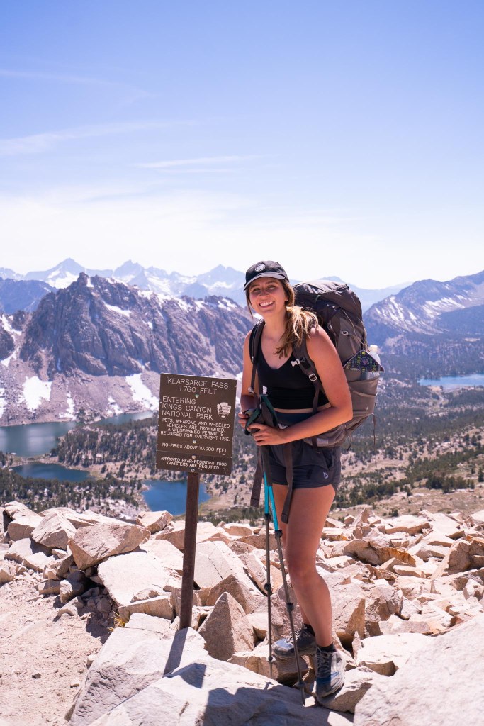
↟ When backpacking Kearsarge Pass to Kearsarge Lakes, the trail crosses into Kings Canyon National Park at the summit of Kearsarge Pass. National Park rules apply ; no pets, bear cans are required, no bear spray is allowed, and you must pack out toilet paper. There is a 2 night camping limit at Kearsarge and Charlotte Lakes; 1 night limit Rae Lakes.
↟ There is no camping allowed at Bullfrog Lake, the lake just beyond Kearsarge Lakes. It is a beautiful lake, and unfortunately has not been taken care of properly by people who visit. I was actually reading a book during this trip called The Last Season by Eric Blehm, a book about a well-known NPS ranger who goes missing in Kings Canyon, and they mentioned Bullfrog being closed in the 80s.
↟ Campfires are not allowed above 10,000 feet in Kings Canyon National Park, and therefore are not allowed at the lakes.
↟ Choose a campsite at least 100 feet away from lakes, streams, or trails. It is very important to do this in order to protect fragile ecosystems. There was a group camping on the shores of the second lake on the grass. Please don’t do this, it causes harm and sets places like this up to be “no camping zones” in the future.
↟ The trailhead for Onion Creek is at 9,100ft of elevation and crosses into Sequoia Kings Canyon National Park (SEKI) at 11,700ft. If you are not used to elevation, you could experience some altitude sickness and should make sure you know the signs and symptoms before your trip.
↟ During the summer months, this trailhead is a primary stop for folks attempting the Pacific Crest Trail to get resupplied for their next stretch through SEKI. You will likely encounter people in the parking lot trying to get a hitch into town, or down in Independence (or Bishop) trying to get back up to the trailhead. These folks are super nice, maybe a bit smelly, and ultimately are extremely grateful for any help you’re willing to give (or cold beers/drinks).
↟ Recreate Responsibly, and Leave No Trace. Stay on trail, don’t cut switchbacks, pack out your TP and trash, and be a good nature-loving individual.


Trail Report
Trip Dates: June 9th-11th, 2022
Total Mileage: 14
Trail Type: Out and Back
Trailhead: Onion Valley
We made it to the Eastern Sierras late, about 12pm the night before. Yosemite National Park is the quickest route for us, but is unfortunately closed from 6am-4pm during the summer unless you have reservations to enter the park. We chose to drive Tioga and camp just on the other side of the park boundaries, before driving into town the next morning.
We stopped at Black Velvet Coffee in Mammoth first, inhaling the churro waffles we had ordered before getting back to the car. From there, we drove south towards Bishop to pick up our overnight permits at the Wilderness Ranger Station. I noticed a ton of people walking around town in relatively the same dusted garb; trail runners, sun shirts and lightweight ball caps. PCT hikers were in town.
When we passed through Independence on our way up to Onion Valley, there were a group of about 10 hikers on the side of the road just after the turn. They stuck out their thumbs in hopes we could give them a hitch, and for about 3 we did. Two of the hikers had started in early April, and one during the first week of May (which is an extremely impressive pace of about 30 miles a day) and had hiked about 700 miles already to the Sequoia Kings Canyon area.

Dropping them off at the trailhead, they grabbed their stuff and flew up the trail. Being a Thursday, the trailhead was full of nearly 20 hikers hoping to get rides out to town, but didn’t have many options as far as day hikers during the week. On our way up the first portion of the trail, we nearly passed a PCT hiker on their way down every 5-10 minutes. It’s what the PCTers refer to as “the bubble”, which is the highest concentrated area of the thru hikers on the trail.
The first few miles backpacking from Onion Valley were steep, and after a few hours we stopped at Flower Lake to pack in a few calories before heading up the summit. There was a Wilderness Ranger across the lake picking up trash and destroying illegal campfire sites. Reid wanted to jump in the water before lunch, and we walked towards the water and noticed dozens of beautifully colored Trout swimming around; perhaps Goldens.
The next miles backpacking up to the summit of Kearsarge Pass were pretty brutal. The trail was steep and rocky, and the sun that day was unforgiving. After reaching the end of the treeline, we could see the summit and the dozens of hikers still funneling down into the canyon. I, who lives at sea level and has not been at 10000+ feet since last summer, was having a bit of a hard time breathing.
PCT’ers on their ascent, had a melodic step they didn’t break for miles. Step, pole, step, pole. Their trail legs were well accustomed to long days at elevation. Eventually when we did reach the summit and could see into the Kearsarge Lake valley, we stopped for a while to rehydrate and admire the views. We chatted with some thru hikers at the top, one of which was eating a huge sub he had bought from Vons a few hours prior.


We reached Kearsarge Lake around 5, and wandered around or a while picking a good spot near the farthest lake. We took a swim in the cold, glacial water before making some food. I convinced Reid to wake up at 4am the next morning to walk along the ridge to Bullfrog Lake to ring in my birthday, and he begrudgingly obliged. So, we turned in early, packed my day-pack, and set our alarms for the early morning wake up call.
Until that Friday in June, I had never celebrated my birthday on trail. By 4:30, we had began walking up towards the trail, and down the ridge to Bullfrog Lake. Almost exactly by the time sunrise started to show, we chose a beautiful spot to sit and make some oatmeal. Did we get attacked by the biggest damn mosquitos Ive ever seen in my life? Yes. But it was still pretty great.


By the time we got back to Kearsage, a nap was in order. After a while, we packed up camp and began to head up to the pass to descend into our next stop, backpacking to Matlock Lake.
Matlock Lake was incredibly quiet compared to the busy trail. We only saw 2 other groups, and only one other person camped at the actual lake with us that night. I was surprised to see hundreds of frogs and (ginormous) tadpoles in Matlock Lake, and never a fish. We went for a swim before lunch, and sat around in the shade reading until dinner. I must have read about 200 pages (and ultimately finished) my book, The Last Season. It was about a SEKI wilderness ranger who goes missing while on duty. Many of the locations in the book I had been to, or am planning to go to later this summer.
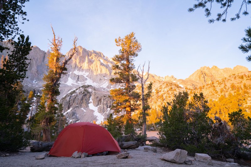
For dinner, I packed a Pork Pad Thai backpacker meal and a Creme Brûlée birthday desert from Backpackers Pantry. The desert was surprisingly good, but could have easily fed a family of 4. Shortly after sundown, we turned in for the night- the wind howling for hours on end. I think I got a total of 3 hours of sleep that night, and could barely function when I woke up to shoot sunrise. I took 3 photos, and immediately turned around to go back to bed. A tired decision that I sort of regret doing. But I can’t blame myself for needing more rest.
A few hours later when the air had warmed enough to make the tent stuffy, we started gathering our gear and packing up for the short trip down to the car. We again, passed dozens of PCT hikers on the way. Some of which, we recognized as hikers who were going down into town on our ascent up the pass. A couple remarked “have fun in town!” when we passed. They thought we were on the PCT too. Best compliment I have gotten in some time.


The parking lot was much more empty then when we arrived 2 days prior. We gave a hitch to a man named John (hiker name unknown), who had started in May and was from Utah. He retired early at 45, and hiking the PCT was one of his retirement goals. He had been training 5-6 days a week at home, doing 20 miles a day to start at the fast pace he was currently keeping. He was also really excited about the ice cream in town. Reid had told John to enjoy the next part of the journey (into Sequoia Kings Canyon, by Rae Lakes), it was one of the highlights of the PCT and his favorite stretch. We dropped John off at a sandwich shop in town, bid farewell and good luck, and drove towards Mammoth; churro waffles on the mind.
Have any questions or comments about this trail? Leave them below!
Happy Hikin’!
PIN IT!


Disclaimer: This post contains some affiliate links, which means if you buy something through those links my blog will receive a small commission at no extra cost to you. This helps me to create free resources like the one you just read, so thank you for the support!


One Response